Thursday, April 28, 2011

Update to Swimming at Grasshopper Point

Last Wednesday we were at Grasshopper Point watching the kids cliff-dive. This happened the next day...

Sedona Fire District firefighters carry a 16-year-old boy from the swimming area at Grasshopper Point.


A 16-year-old Sedona Red Rock High School sophomore was flown to Flagstaff Medical Center after sustaining a head injury after falling at Grasshopper Point on Thursday, April 21.

The drop into the water at Grasshopper Point is estimated to be roughly 30 feet.

Emergency crews with the Sedona Fire District responded to the call at roughly 1:30 p.m. following an injury report at the popular hiking spot.

According to witnesses a number of students from Sedona Red Rock High School were cliff-jumping in the area when the boy fell.

The extent of the boy’s injuries is unknown at this time.

Tony's Note: He was later released from the hospital.

Tuesday, April 26, 2011

Once in a lifetime, twice in one day!

You won't believe what happenned again today.

No need for any words, pictures will suffice.


Zion and environs...

A couple of things for me to remember when I look back on this blog...

It really is amazing how different the scenery can be within a relatively close proximity to each other. Bryce Canyon is like dripping sand castles, Zion has huge rounded layers like Jabba the Hut, the Grand Canyon is, well, it's the Grand Canyon, Arches has the arches (who knew), Canyonlands has layers of deep canyons, around Lake Powell it is like a lunar landscape and you can't beat the slot canyons in Page only a few miles away. What was going on all those years ago to have so many different layers of different types of sediment? One can easily see how the earth was pushed up and delineate the different layers from one area to another.

The other is how distance is sort of meaningless. With so much open area one thinks nothing of taking off for many hours for another experience. It would be like being in our home in MA and saying, "after lunch, let's go to Montreal."

With that in mind, recently, at about 1pm we decided to head out to go to Zion National Park. It would take about 6 hours to get there. We had planned to go there on our way home, but at this point, we may take a southern route to avoid any bad weather. I don't want to blog about tornadoes.

Once again, we were amazed a the beauty of the national parks in the west.

Coming in from the east, the first formations you see are huge, layered, rounded masses that could look like a millennium's worth of cow pies.


Once you go through a couple of man-made tunnels drilled through the mountains, you come into Zion Canyon which seems totally different.


We stopped at the Virgin River Bridge for a view of the muddy water


And made it through the park at sunset on our way to Cedar City for the night


The next morning we took a quick detour through Kolob Canyon at the north end of Zion. Also spectacular. Then we drove back through Zion in the opposite direction. Things look totally new in the opposite direction.
Judy drove so I could enjoy the scenery


We had our Utah Off-road book with us so we decided to take a few excursions into the outback on our way home. First stop was a place called Paria (pronounced Par-eah, like Maria). This was a spot settled by the Mormons in the late 1800's. I guess they stopped there because there was water but now all that is left is an outhouse and a cemetery where most of them are buried. Those in the cemetery either died from the elements or were killed by Paiutes. It was a tough life back then. We were amazed at the scenery but I'm sure that wasn't high on their mind.


Our last adventure took us into the lunar landscape on the Utah side of Lake Powell. We thought we could make it down to the lake itself, but the trails were not marked and it was very difficult to know where we were.
Here I am trying to find our way with my GPS


This place was so different than anything we had seen so far as can be seen by this overhang we drove under.


I had plenty of gas (this time) and there was plenty of daylight left, but it was getting late, so after climbing up and down the trail through deep sand, we decided to find our way back to civilization. On the return, we crossed paths with a couple in a pickup who asked if we knew where we were. Neither of us knew our exact location but were having fun finding our way around.

We got the last room at the Courtyard in Page and spent the night before heading home the next morning.

Note to self...

For my own future reference...
We have kept the hummingbird feeder going but those guys are going through a couple of cups of feed per day. Some water may be evaporating but still, there are probably a half dozen or more birds that hit it all day long, maybe more. This morning, the feeder was empty again and there were birds checking it out and looking at me to fill it up.
Anyway, Judy and I were on the deck waiting for the javelinas to stroll through the yard. We had left the screen door open. When we came back in the house, I heard some noise and thought something was going on downstairs. It turns out one of the hummingbirds was in the house, flying against a window trying to get out. I tried to shoo it away from the window towards the door, but it was insistant on banging its beak against the window. Finally, it got tired and sat on the sill. I slowly approached it and wiggled a newspaper under its feet and lifted it up. It perched on the edge of the newspaper and flapped its wings a bit, but I was able to carry it across the room to the open screen door and let it take off. Judy didn't dare move to take a picture in fear of scaring the guy but we were both pretty pleased to help our buddy out.

Wednesday, April 20, 2011

Cleaning out my Camera (Update 2)

Update 1. Added more YouTube videos.
Update 2. Added photos from Grasshopper Point

It used to be cleaning out a file drawer, but now it is cleaning out my card on my camera. So, these will be random photos or thoughts just for my own keeping to get into my blurb book when this blog is done.

I've also updated the slideshow on the left with a few new (er) paintings. Now that I remember how to do that, I'll try to keep it more up to date.

Have had great luck with the Hummingbird feeder. I've had 5 humming around at a time and 3 at the feeder. I think the females can share the feeder, but when a male comes along, he chases everyone else away.
Here a are a couple of female Ana hummingbirds chowing down


We've had some visits from Javelinas. Here are a couple that walked through our patio the other morning. I wonder where they are during the day.
Mom and baby looking for breakfast


We finally took a hike on the Huckaby trail. This trail runs about 3 miles, one way, from Schnebley Hill along the creek across from our place to the famous Midgely Bridge. If you can't cross the creek at the bridge, you have to go back the 3 miles. So, we just went as far as we needed to see our house from the top of the trail. Probably about 4 miles round trip over an up and down trail with a fair amount of climbing and then going downhill.
Our place from the Huckaby Trail


Judy working her way down towards the creek on the Huckaby


Near our place is a scenic area called Grasshopper Point. It is right along the creek and a favorite picnic spot for locals, especially you kids. I guess the water is deep enought at this point to jump in as these kids can attest.


Grasshopper Point is also the location for the trailhead for Allen's Bend Trail. This short trail is very close to civilization but gives you the impression that you are out in the wilderness. Can you believe that the main road to Flagstaff is only 100' or so above Judy's head?


Here are a few videos I took when Curt and Terry were here. The Broken Arrow trail is a great hike but also a lot of fun to drive on. It is a very popular trail for the Pink Jeep company that runs off-road tours in Sedona. I attached my camera to my windshield and let her rip. The scenery is spectacular.
Check 'em out.

Click Here for Up to Submarine Rock .
Click Here for On top of Submarine Rock .
Click Here for Heading down Submarine Rock.
Click Here for On the way to Chicken Point.
Click Here for Chicken Point.
Click Here for Mushroom Cap.
Click Here for Some Slick Rock.
Click Here for The Staircase. Too bad my camera got jostled out of position on this one, but you get the drift.

Stay tuned for more updates with additional photos.

Monday, April 11, 2011

Fund Raiser for Pancreatic Cancer Research


This past weekend, Judy and I went home to join with Mike Noble and his extended family in a fund raiser for pancreatic cancer research. Mike is not only fighting his battle but is also doing whatever he can to raise funds and awareness for future generations who may have to combat this dreaded disease.
Mike's team raised more than $35000 for this event. The event itself raised about $80000, so the Nobles brought in almost half of that. Thanks to our friend, Bob Coates, for dropping by the starting line to offer his support.

Judy and I thank those of you who donated for this "Noble" cause. Follow this link if you'd like to donate.


Mike was really surprised when we showed up at his house the night before the event. It was a no-brainer for us as we were already planning to come home to celebrate the end of his treatment and his 59th birthday. Walking in the fund raiser was icing on the cake.
It was a great day. What a turnout in support for Mike. He had the largest contingent of any team. Of course, he also had the largest family of any other team.

Here is the team photo


There was a 10K run, a 5K run and a 5K walk. Some of the Noble clan decided to do the 10K run. Here are a few photos of their efforts.
Matt after completing his run


Here's Mike cheering Emily on...


Kyle has us in his rearview mirror


Here's Hillary and friends about to cross the finish line


This walk was terrific. Not only were we raising money for a great cause, but we got to chat and schmooze with friends and relatives along the way. Mike was in great form (having run 2 miles earlier in the week) and looked great crossing the finish line.
Matt joins his dad as Mike crosses the Finish Line


Not to be outdone, here comes Pam


Judy and Jim had a great time chatting along the way


And Uncle Marc came flying across the Finish Line


A number of members of the Nobles team did well in the running events. Here are Kyle, Emily and Matt who all won medals for having pretty good times within their species.

Afterwards, we all went to Pizzeria Uno for a little after-the-fact carbo loading. Mike gave a very warm and heart-felt speech thanking us all for participating. When Mike expressed his gratitude to us for helping out, someone yelled out, "It's because we love you." That summed it up for all of us who took part in this day. The last official act of the day was to celebrate a couple of birthdays with some gluten-free cake.

Then it was back on the plane for our return trip to Sedona for the last three weeks of this year's adventure.

Tuesday, April 5, 2011

Busy Day today

I finally got off my butt (or actually "on" my butt) and created 4 new posts today that document some our activities for the past few weeks. Take a look and feel free to add any comments.

Rte 66 and Hoover Dam

We recently read that there is a road off of old Rte 66 that leads to the bottom of the Grand Canyon. It is one of only two roads that can do that, the other being the road to Lee's Ferry where the Grand Canyon officially starts, near Page. We were sitting around sunday morning talking about finding this road and touring Hoover Dam while in the area and enjoying parts of the old Mother Road. Judy said, let's go. I hemmed and hawed thinking it was "too late to start anything new", but she insisted and I'm glad she did. Another fun adventure to add to our memory banks.
We hit the road and stopped in Williams AZ for lunch/breakfast in the Pine Country Cafe. Nice friendly place with good service and food. Then off to Rte 66 starting in Seligman, AZ. Had we not been so hungry, we could have waited for this place in Seligman.
Sound Appetizing?
Does anyone remember the old Burma Shave signs on the highways before the interstates? Rte 66 has 'em. 
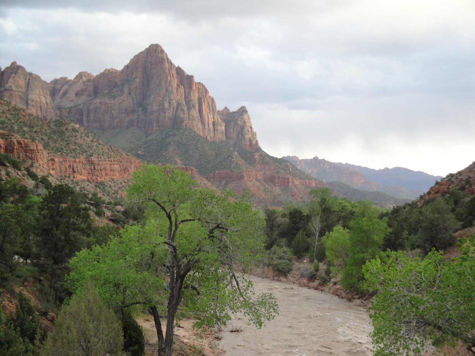
From there we headed to Peach Springs which is on the Hualapai (who-wall-a-pie) Tribal land. The road to the canyon is across from the Hualapai Lodge where you need to pay a fee for access to the road. The road leads through a depressing neighborhood of dilapidated homes before it passes through a gate and onto the dirt road that runs 21 miles to the canyon floor. This was really cool. It was a real thrill.
Some photos....


Judy at the Wheel

Judy coming out of the weeds.


I took lots of photos, but I'll try to show the panarama with a video.

BTW, saw these animal tracks in the mud. Put my Swiss Army knife next to them to show relative size (Old CSI trick). Can anyone ID them?


Retracing our path back to Rte 66 was equally impressive.


We spent the night in Kingman before heading to the Hoover Dam the next morning. We had seen the new bridge over the dam when it was under construction, but I wanted to see it completed and walk out on it. Here is a view of the dam from the bridge.

It is called the Mike O'Callaghan - Pat Tilman Bridge. I think O'Callaghan was a politician in Nevada and Tilman was the ex-Phoenix Cardinal who quit the NFL to join the army and was killed by friendly fire in Afganistan.
We took a tour of the Power Plant. What a madhouse. Seems like everyone is on Spring Break every week out here. Even the busloads of Italiens and Germans.
Here are the turbines on the Nevada side that help provide electricity to over a million homes.

View of the bridge from the dam.


Finally, we crossed into Nevada and headed south toward Laughlin. Laughlin is a mini Vegas on the Colorado River. It has a paddle wheel casino called the Colorado Belle. We didn't stop there. But, the scenery coming into Laughlin from the west was incredible. Worth the detour. No photos...

We headed into Az and looked for the highway to Oatman. It was a dirt road that crossed through some really stark scenery. There were many tracks leading off the main road. We took one just to see where it went...

Then got back on the main road...

At the end of the dirt road, we found the town of Oatman, named after a family that was massacred and their two daughters enslaved by the local Tonto-Apache.


There are wild donkeys left over from the mining days that wander the streets.


Here's one that actually walked into a shop.


By this time, we were toured-out. So, we bought a couple of ice cream cones and got in the Jeep. We had more than 4 hrs to get home, so Judy took out her needlepoint and I put the pedal to the metal and we were home in time to watch the 2nd half of the UConn-Butler debacle.

I thanked Judy for insisting that we take this trip. It was really fun and fascinating.

Home Draw Tank Trail

Sarah came up with a Jeep tour from our Off Road book. The trail was called the Home Draw Tank Trail. It was rated fairly difficult at times and had good scenery. It starts on a dirt road east of I-17. The roads work their way up and down narrow pathways over a lot of mud, rocks and creek crossings.
This one looked deeper than it was, but you never know what is on the river bottom until you drive into it.


Here I am waiting for our official photographer to catch up to us...


Almost as soon as we got to an open area, Judy spotted a herd of elk about 100 yds away making their way back into the treeline. I took a quick shot and blew it up so you can see a few elk in the bottom left.

No wonder they head for the trees as it seems that if they are out in the open, they become lunch or dinner for another critter. The open area was strewn with bleached bones.

Notice the skull on the right in this photo


Much of the rest of the trail was in open areas with lots of jagged rocks in the way. The county roads were not well marked, in fact not at all, so somewhere along the line we missed a turn. We ended up among a few shacks and corrals with a solitary bull standing in our way.


We went around him and found the road by going into and out of one of the corrals. Or so we thought. That road eventually evaporated so we back tracked and found another that also evaporated. At this point, I was getting a little nervous about gas. I had plenty, but not if we kept going in circles and if we hit too many gas guzzling mud climbs. (of course, I kept my mouth shut for a while about the gas. No point worrying anyone else).

Just before we stopped for lunch I spotted another elk antler next to the road.

Tony, Sarah and Antler on the Home Draw Tank Trail

What are the chances? We found one 2 years ago and then another one, even bigger, the other day. Now both Judy and Sarah have a souvenir they don't know what to do with.

Finally, by using our garmin and Bill's iphone gps, we got back on the right track. We had missed a turn near the old shacks and bull. If we had only checked the book, it told us to pay attention. Oh well.

The rocky path became a dirt road with beautiful views toward the south on our way back to Camp Verde.


We gassed up, bought a couple of ice cream sandwichs and headed home. I had "made" a pulled pork so we stopped at Basha's supermarket to buy the rest of the fixins'. We finished things off by dining on the Sullivan's porch and enjoying a fire before calling an end to a great day.


Oh, if you are wondering what ever happened to that elk skull from the previous photo. Can you guess?

Check this out!


Soon to be on display on Judy's Artifact shelf in our kitchen. Good Grief.