We drove about a mile or so then took CR237 (called Snow Flat Road), over Cedar Mesa. Snow Flat Road was part of the old Mormon Pioneer Trail that led to San Juan. This road, about 20 miles long, had terrific vistas in all directions as you got towards the top of the mesa. Near the very top, the road got a little more challenging but nothing the Jeep couldn't handle. Here we are passing over a sketchy section near the top.
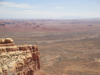
Once on top of Cedar Mesa, we had clear sailing, only seeing a few vehicles coming in from the other side, until we reached route 261. Taking 261 south, we were heading for the Valley of the Gods which we had visited before with the Nobles. As soon as we saw signs pointing to John's Canyon, I knew we must be getting close. But I wasn't quite prepared for what was ahead. We could see Monument Valley way off to the south but couldn't see anything of the Valley of the Gods which should have been just to our left. That was because we were on top of a large plateau and the rock formations were in the "valley" below.
When we saw the signs warning trucks of a steep descent
and then the paved road turned into a gravel set of switch backs that dropped us from the plateau to the valley floor.
This was the Moki Dugway.
Here are a series of swichbacks that drop you 1100 feet.
The road was built in 1958 to transport uranium ore to a processing plant in Mexican Hat. It really was amazing to be driving along on a seemingly flat road and suddenly hitting this steep drop. But, it is very typical of the landscape in this area. There might be steep cliffs on one side of the road and a very deep canyon on the other. The way the land has been created, layer by layer, over millions of years and then patiently eroded over more millions of years is astonishing.


No comments:
Post a Comment