Saturday, March 31, 2012

Flaming House Ruin

Our next stop was to find the Flaming House Ruin. This ruin is located in a canyon off of rt 95 west of Bluff. The images of this ruin that one finds online are spectacular. In reality it is not quite as spectacular but it is still mighty impressive. After a leisurely half hour walk criss-crossing a dry creek bed we reached the path up to the ruin. Luckily the creek was bone dry as we crossed it many times and even walked in the creek bed. In the rainy season, it would be pretty messy hike. There is a very short bit of slick rock to climb up to view the ruin. There are several dwellings snuggled under an overhang. The sun reflecting off the slick rock lights up the overhang, giving it the name Flaming House Ruin. The photo to the left was taken around 11am before the sun came over the overhang.

There are many such ruins in the 4 Corners area. They were inhabited by the Anasazi for about 800-900 years until they abruptly picked up stakes and moved toward the south. The reason for that is unclear but most archeologists feel that it was due to a sustained drought.

There were a few nooks and crannies that it was fun to poke around it...Here's Judy thinking about doing some climbing

And I got a little wedged under a boulder and was about to go all "127 Hours" when Judy reminded me that I could easily just pull my arm free.

On the way in the canyon, we spotted this rock which reminded us of one of our favorite books, Angle of Repose, by Wallace Stegner. With a little more angle, this particular rock won't be reposing much longer.

Thursday, March 29, 2012

Butler Wash near Bluff Utah

Butler's Wash runs along the east side of the Comb Ridge in southern Utah. It runs south to north from rte 163 near Mexican Hat to 95 near Blanding. The Sullivans and the The Donovans drove in from the southern end. We were looking for the Wolfman petraglyphs in a small canyon along the trail. After about a mile, there is a dirt road on the left just before the first cattle crossing. It leads to a small parking area and further to a area of slick rock just before a path that should lead one to Anasazi wall art.

We parked the Jeep on the slick rock and followed the trail, what there was of a trail.

The area is noted for the Wolfman petraglyph which was not that obvious to find. We walked around the ledge looking across the ravine trying to spot the wall art. On the opposite side of the ravine are a few ruins. Here's Judy looking across the way at one of the ancient cliff dwellings.

Using binoculars, we finally located the wall art which was a distance away. After climbing over/between some huge boulders, we picked up the trail that lead from the left end of the slickrock. The pathway led along a narrow trail hugging the ledge and then beyond a large alcove. The wall art was located in the dark patch of desert varnish located to the right of the alcove.

Bill and I worked our way along the ledge and under the alcove to come to the Wolfman art work. Here's Bill heading down from the alcove to get a view of the wall art.

This site was definitely worth the detour. It took a bit to actually find the wall art, but we are glad we persisted. Here is a great example of wall art from the Ancestral Pueblans

Sunday, March 25, 2012

The Oak Creek Homestead Trail

The Homestead trail is a very interesting and difficult side trip off of one our favorite drives. We have taken most of the 9845 route before and it has some interesting scenery and it is close to town. We follow 9845 from 89A about a mile south past Upper Red Rock Loop Rd. At a junction of about 4 trails, we turn right onto 9845H. I assume the H is for Hard. In fact, this part of the trail is rated Extreme on my Red Rock Ranger District map. The trail winds its way up and down over fairly large rocks along a shelf overlooking a canyon below. I had to pull over to the edge of the shelf to let an oncoming tourist vehicle get by, which was a little disconcerting.

We had been to the beginning of the extreme section before, but opting not to try it as it was late in the day and I didn't expect anyone else to come by to help in the unlikely event that I might have needed assistance. This time the Kobeys were with us and Lynn urged me on. The road drops down a relatively steep ledge with huge drops between the boulders. It was short but sweet. Once down the ledge the trail leads to an old abandoned homestead. Here's Lynn checking it out.

At some point I'll get some photos of the crawl down and up the rocky ledge. But, in the meantime, the trail leads to a campsite along Oak Creek and the trail crosses the creek and picks up on the other side. Here we are contemplating the creek crossing.

Discretion got the better part of valor and we did not cross the creek. It really wasn't much a choice as we thought the creek must be fairly shallow but couldn't see the bottom. With no other Jeep to help us get out if we got stuck, it wouldn't have been a good idea to try it.

But there was beautiful scenery along the creek.

Sycamores

And a really cool rope swing that looks like it could be fun (for someone other than me!)

We have been back there one time since to have a picnic. We even bought some camp chairs at ACE even tho we have at least 3 at home. So we pulled up to the edge of the creek and unloaded and set up the chairs. Then I kiddingly asked Judy where the lunch was. After scouring the back of the Jeep we realized we had left it on the counter. So, what else to do but read for a bit and then go out to lunch at one of our favorite local spots, Nic's.

BTW, check out the color of the creek in the photo on the right. This was taken on our first trip here while the photo above were taken on the second trip. After the snow storms here a week ago, there is a lot of runoff that adds a lot of mud and silt to the creek and raised its level quite a bit. Interesting to see how quickly the creek can swell from snow melt and runoff.

Monday, March 19, 2012

Grand Falls, Petrified Forest, Monument Valley and Antelope Canyon

Our trip to Canyon De Chelly included a number of very interesting stops on the way and way back. We left Sedona and headed east on I-40 to Winona and then towards the town of Leupp.

Grand Falls

From the main highway, we took a dirt road to find Grand Falls. There are no signs for this amazing site. You just have to know where it is. We had been there before so I knew it was about 9 miles down this scrubboard road, rte 70. This is a spot where the Little Colorado river flows over a series of falls before turning sharp right to make its way to the Colorado river and the Grand Canyon. There is an umarked track to the left at about mile 9 that leads to a dirt parking area and overview. I missed that turn. When I found my front wheels actually in the Little Colorado river, I knew it was time to back up and find the path. I've blogged about it before, but here are a couple more photos. There hasn't been much rain here so there wasn't much water. But, Flagstaff just got two feet of snow, so maybe there'll be some snow melt flowing through soon.

Over the falls.

Heading toward the Grand Canyon

Our next stop was Winslow for lunch

then to Holbrook and the south entrance of the Petrified Forest National Park.

Petrified Forest

It is a barren area where once huge trees grew. The trees were knocked down and covered over with water and silt. Over time, elements in the water penetrated the bark of the fallen trees and replaced the wood with elements that made up stone. The different elements have beautiful colors.

We also had spectacular views of the Painted Desert

You are not allowed to take any petrified wood from the forest. But, you can buy souvenirs at the gift shop at the exit or stop at a huge wharehouse store outside the park at the south entrance.

From there we headed to Chinle. We picked up an hour of daylight due to the fact that the reservation "sprung forward" while AZ did not. But, we barely had time to take a quick drive along the rim and then go out to dinner. They roll up the sidewalks up early in Chinle. See the previous post for my great day in Canyon De Chelly.

Monument Valley

After the great Jeep tour in Canyon De Chelly, we headed directly to Monument Valley. "Directly" is a loose term as we drove north, east, north again and south to get there. It took a few hours but we got to see the sun set over the valley from our balcony.

and the sunrise...

We took the self-guided 17 mile drive through the valley stopping at some of the key locations, like...

The 3 Sisters

John Ford's Point where many of his westerns were filmed

and the Mitten

We ate a later breakfast at the View before heading to our last destination. BTW, just about everything at the View has improved since our first visit a few years ago. All they needed was a little experience to improve everything from the front desk to the dining room. Of course, the View itself can't be beat.

Lower Antelope Canyon

Our last destination was Page and Antelope Canyon. There are 2 slot canyons in Page, Upper and Lower Antelope Canyon. We have been to Upper several times now. It has a wider top than the Lower canyon that let's in more light while the Lower has a narrow top that let's in less light but may let in more dramatic shafts of light when the sun is in the right position. As we were arriving in Page, it was about 12:15 and the sun was pretty high in the sky, so we decided to take the tour of the Lower Antelope Canyon and hope for some dramatic photos.

Just after walking into the canyon, you may be greeted with a beam of light.

If you are lucky you can get the whole beam from the top of the canyon to the sandy floor. Unfortunately, there are tons of people who want to take the same photo and the guides move you along fairly quickly. The guides are very helpful in pointing out good photo ops. Here's one of Judy that our guide pointed out
I never would have noticed this on my own.

This canyon is really fascinating, but you've got to catch the light when if is overhead. That takes place during the peak tourist season, so it can get very crowded. The Upper is less dramatic but has more varied terrain once you crawl into the slot and it is usually much less crowded.

We had burgers at Slackers in Page and headed south for our 3.5 hour drive back to Sedona with a pit stop at Cameron's Trading Post. We got home in time to order a few pizzas and watch a few March Madness brackets get busted. Not a bad couple of days.

Saturday, March 17, 2012

Canyon De Chelly - Chinle, AZ

Ever since I saw that a Jeep Jamboree was held in Canyon De Chelly (pronounced Shay due to a mispronounciation and spelling of the original Navajo name), I've been anxious to drive my own Jeep there with a Navajo guide. The jamboree is in June, so I would not be around to participate so we decided to organize a trip to the northeast of Arizona with Tom and Peg Wilfong for this dream trip of mine. In 3 days and 2 nights we covered Grand Falls, Petrified Forest, Canyon De Chelly, Monument Valley and Antelope Canyon. This post is about Canyon De Chelly.

Canyon De Chelly is a very meaningful and historic location for the Navajo. It is located in northeast Arizona in Chinle on the Reservation. One can tour the canyon in an open truck bed, a private guided tour or in your own vehicle with a Navajo guide. We had taken the open truck tour a few years ago and I've always wanted to go back in my own vehicle. So, we packed bags and headed out early tuesday morning. We had a few stops which I'll blog about later and had our lunch in the Brown Mug Cafe in Winslow (Navajo tacos all around). I put on my ipod and we listened to the last 5 chapters of Blood and Thunder by Hampton Sides which deals mainly with Kit Carson and the round-up and relocation of the Navajo Nation. This gave us all some of the historical significance.

I had contacted the Jeep Jamboree people and they gave me the name of the guide they use. His name is Daniel Staley. We arranged to meet Daniel at 9am at the Visitor Center. When he wasn't there at 9:15, we got a little worried. After one of the other guides volunteered to call his son, Leander, Daniel arrived. He had transmission trouble and had to catch a ride with one of his friends. It was a beautiful day so I wanted to take the hard top off so we all could have a good view of the canyon walls. After a bit of a struggle, we pulled the top and left it next to a corral belonging to one of Daniel's friends. I was glad to see it there when we got back.

The canyon is made up of two canyons, Canyon del Muerto and Canyon De Chelly. We (I) wanted to see parts of both canyons. The opening is quite wide and we had to drive through a lot of water to get to the "Y" for the split.

Along the way, Daniel pointed out numerous examples of petroglyphs (carved)

and pictographs (painted) that date back hundreds of years. Some show native signs and tell stories and others show the Spanish soldiers on horseback.

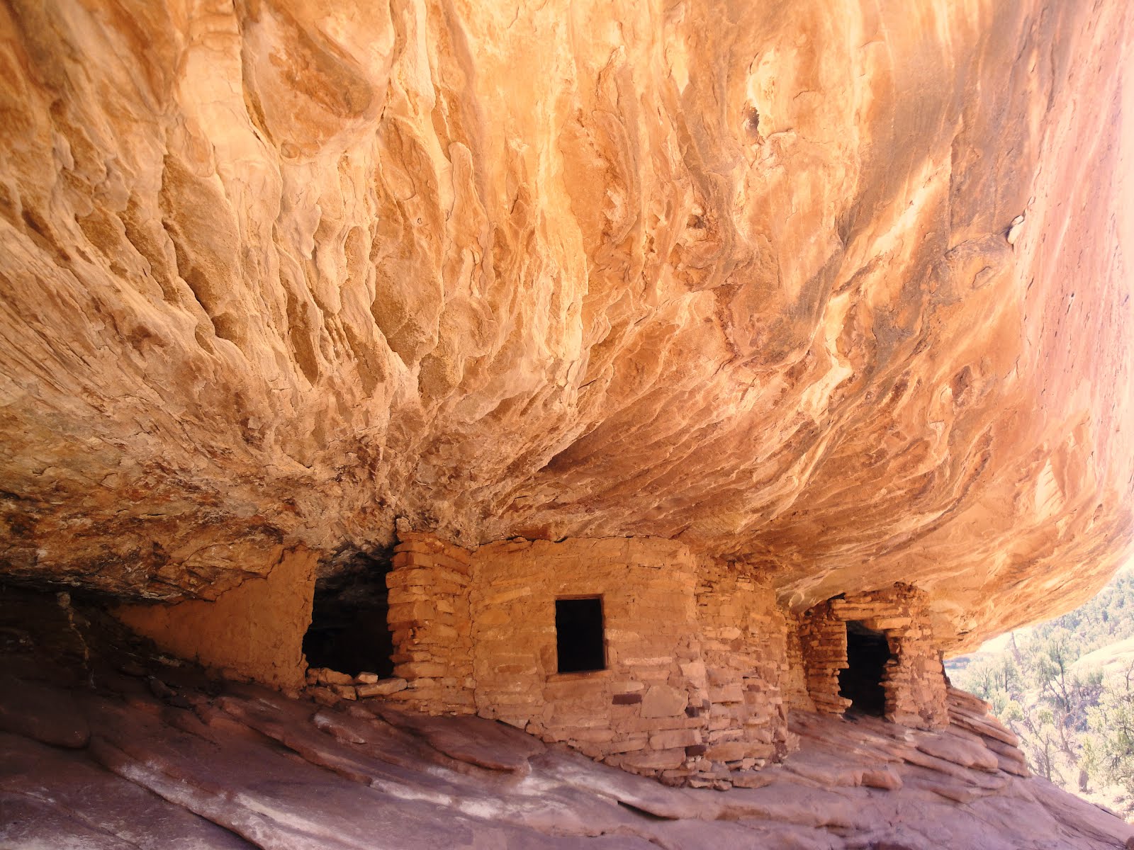
There are many examples of cliff dwellings along the way. The Anasazi lived here over 1000 years ago and built their homes under the overhangs of the canyon walls. Over time the canyon floor has eroded away leaving the dwellings higher in the walls than when they were built. Maybe you can make out the dwellings in the overhang in this photo.

There is a lot of livestock in the canyon. The horses and cattle roam free for the summer. They are branded so they belong to different families who still have property in the Canyon. Daniel has sheep and cattle that he rotates from the canyon floor to the canyon rim to graze.

My goal was to get to two places, Spider Rock and Fortress Rock. We took a right at the "Y" and headed for Spider Rock. Spider Rock is the home of Spider Woman, an important deity to the Dine (Dee-nay or Navajo). The rock is 800 feet high and its erosion began some 230 million years ago. Spider Woman helped the Dine survive when they first came to inhabit the land. She taught the Dine the art of weaving which they still do. Here is a modern Spider Woman with Spider Rock in the background.

Our guide, Daniel, told us the story of Spider Woman. He told us how parents use the fear of Spider Woman to get their kids to behave. Kids are threatened with being captured by Spider Woman and eaten alive if they don't obey their parents. Daniel's mother used this on him when he was young. When he tried the same thing with his kids, his son said he would get Spider Man to help him. So much for tradition. Here he is telling us the stories.

I love this photo.

On the way back to the "Y", we stopped at Daniels' Hogan which the Navajo use to live in and to hold rituals. He built it himself and he spends most of the summer there tending to his livestock. It is sparsely furnished with a chair, a couple of cots, a camping stove for cooking and a stove for heat.

We had to ford a number of creek crossings (we counted 26) which was a blast to power through. None were very deep but some had steep banks that we had to fly down or grind our way up. Lots of fun.

Here I am with Daniel with some of the mud splatter from the creek.

To get to our next stop, Fortress Rock, we had to go quickly so Daniel had me take the short cuts through the water skipping the trail that meandered through the canyon. At one point I felt like the African Queen as we drove through a stretch of the creek with trees on either side brushing against the Jeep. At one point we drove under a huge overhang.

I remember parking under this overhang in the open truck but it was on dry sand. This time it was much more fun in the water. I had to drop Peg off to take a picture while I made a U-turn and tried it again. Wheeee!

Our last stop was Fortress Rock. Fortress Rock is in Canyon del Muerto (canyon of death, canyon of the dead, dead man's canyon, you get the drift). In the effort to round up the Navajo in order to force them to give up their land and march to another location, Kit Carson initiated a "scorched earth" policy. This was put into action to starve the Navajo and relocate/imprison them in New Mexico. The siege laid down by the US Army drove the Navajo who were in Canyon De Chelly to the top of this rock.

During the winter of 1863-4, the Navajo in Canyon De Chelly finally gave in and, along with Navajo from other parts of the region started the "Long Walk" to Bosque Rodondo. In 1868, William T. Sherman realized that this "experiment" was not working and released the Navajo who returned to their original home in what is now the reservation in Arizona.

This was truly a great adventure for us. I think we all got a lot out of the culture, history, scenery and off-road fun. This is an experience I will remember and treasure for a long time.

Sunday, March 11, 2012

Wilson Canyon

Yesterday we had a quick visit from Michael and Joanne Crehan and their daughter, Kim. They are in Scottsdale for the week and swung by Sedona for the day. The Crehans are originally from Walpole and Joanne is the daughter of Alice Cosman and she was in Judy's first teaching class as a fifth grader. More about them later when Joanne sends some pictures.

We got up this morning and had a list of things to do. So we decided to take a hike before it was too late. After some contemplation we chose Wilson Canyon as it relatively short and close by. The trail head is near the Midgley Bridge, for those who know the area. The trail splits off from the more challenging Wilson Mountain trail and runs down hill along the creek. There are beautiful vistas almost immediately on the trail.

How's This?

Soon after taking the photo, I caught up with Judy as she made her way down toward the creek. The path criss-crosses the creek in a number of places but there was no water to worry about. So crossing is very easy.

The trail climbs and descends back and forth along the creek. It really has a nice variety of terrain. Much of it is in the shade which would make it enjoyable in the hot weather.

Near the end of the trail, there is a short, steep pathway that leads to an open area that gives a great view of the surrounding landscape.

On the way back, Judy stopped to admire the scenery where the creek would flow over huge rocks on its way down to merge into Oak Creek. Maybe you can see her on the right side of the photo. This would be a great spot when the water is flowing.

Wilson Canyon has definitely made our short list of trails to take with our visitors. It has varied terrain, terrific scenery, isn't too long and, best of all, we don't have to drive through downtown Sedona to get to it.

Monday, March 5, 2012

Alive and Kickin'

We haven't had anything too unusual to post but we are still alive and kickin' here in Sedona. Our daily life is a lot like at home, only different.

For starters, we do have strange creatures chowing down on the grass on our patio. We've had these critters before but they seemed to have increased a bit in population.

Another critter that was around a lot last year was Tucker the Cat. We even had food in the house to feed him. He seems to have been driven off by a couple of younger cats who have taken over. If there is the slightest crack in the door, one of them will come in and make himself at home. Here he is reading the Van Gogh book while Judy takes a nap

We have been getting out of the house too to take some hikes. We like Marg's Draw which links with other trails so we can extend it if we want to. There is great scenery along this trail even tho it is very close to downtown Sedona.

We have wanted to try to find the location of the subject of a painting we bought at the Plein Air Festival a couple of years ago. It is the "Swimming Hole" by Josh Bean. We think it is at the end of Parson's Trail. So we set out to find it. The trailhead is 12 miles down a dirt road from Cottonwood and then an 8 mile R/T hike. So, after stopping for lunch and a coupla beers at the Grasshopper Cafe in Cornville with Bill and Sarah , we decided to just find the trail head. Here is a view from the top of the cliff overhanging the trail. It is a steep descent but then (we understand) relatively flat for most of the trail. We'll do it at a later date.

Today we took a hike on a loop that goes for a couple of miles but is very hilly. Lots of ups and downs. But, great scenery. Our loop consisted of two trails, the Jordan and the Cibola and included great views of up-close and distant formations. Here's Judy resting at the top of the saddle on the Cibola trail with a view of the Fin (aka the Sail) in the background.

This year we have neighbors in the guest house by the car port. There are two lovely young ladies who are in Sedona for an intense PT workshop. They are both physical therapists at a hospital in St Croix. Sayi and Venne spend long hours at the workshop but had time to watch the Oscars with us and we all went out to dinner at Casa Bonita before Sayi went home.

Venne will be here another couple of weeks so we hope to see more of her and show her a little bit more of Sedona. (and I want them to play my March Madness Pool) .