Wednesday, May 9, 2012

Bent's Old Fort

Bent's Fort is located near La Junta, Colorado. It is a trading post along the Santa Fe Trail that was built in the 1830's by Charles and William Bent and Ceran St. Vrain.

This was a very active and influential trading post that was visited by trappers, soldiers, traders, settlers and native Americans. At any given time, 6 or 7 languages were spoken at the fort. It was sturdily built and meant to last many years. Beside the traders and transients, there were 60 or so permanent residents and many visitors could enjoy the fine dining and conversation found at the fort. It was a place for cultural exchanges and a place where such luminaries of Manifest Destiny as Kit Carson and John C. Fremont would spend some time.

There are many school outings at the fort and the National Park Service has very good interactive sessions with local school kids.

Charles Bent, the acting governer of New Mexico was killed in the Pueblo Revolt in 1847 and soon after his brother William moved to a new location. It is thought that he tried to burn the old fort to the ground before relocating. Thanks to detailed drawings by a Lt. James Abert, who passed time at the fort in 1845 and 1846, the fort was rebuilt to its original specifications in the 1970's.

It really is a treat to be able to soak in some of the history and try to visualize what the west was like in the early days of our country.

Saturday, May 5, 2012

The Joys of Taking the Back Roads

While driving along a stretch of secondary road, I spotted a horse standing in a field. Nothing too unusual as there were lots of cattle and horses grazing in fields along the way. But, as I passed by, I saw something on the ground below the horse, which, in a fraction of a second, I thought was a dead colt. But at that moment, it raised its head for a second. I turned the Jeep around and walked to the edge of the field to take some pictures. Sure enough, it was new born colt just becoming aware of its new existance.

This colt was only recently born as we saw it try to stand and take its first steps. Unfortuately, I only got a photo of the sky when the colt stood for the first time.

But very quickly, it was on its feet and feeding. By the time I got back in the Jeep and was heading in the right direction, the colt was already jogging around the field under the protection of its mother.

This was really an interesting natural experience. I was so happy we were taking the back roads for some of our travels.

Southern Colorado - Moab to Pueblo

The trip across Southern Colorado was terrific. We took the scenic route from Moab to I-70. 128 is the route that runs along the Colorado. We stopped for breakfast at the Red Cliffs Lodge

and took in some of the local scenery there.

The road parallels the Colorado

and winds its way below the massive canyon walls.

Once you exit Canyonlands and you reach I-70, the landscape changes completely and we meet other critters who are enjoying the scenery.

We crossed into Colorado at Grand Junction and picked up route 50. This was a beautiful drive through many quaint towns like Montrose and Gunnison. The road crosses several summits. After crossing the Continental Divide, where the rivers would now flow towards the east...

We came upon Blue Mesa Lake. This is a reservoir that is the largest body of water in Colorado and a great spot for fishing and boating.

From there we picked up the Arkansas river, which looks like a creek at its headwaters but will be a major river by the time it dumps into the Mississippi.

Rte 50 followed the Arkansas through Bighorn Canyon on our way to Pueblo. The Arkansas River was the border between the U.S. and Mexico in the early 1800's and many of the towns retained their Mexican names, like Pueblo, La Junta and Las Animas to name a few

Our goal was to get to Pueblo which had a nice mixture of old and new. There is a PBR (Professional Bull Riding, not Pabst Blue Ribbon) headquarters...

and a popular Riverwalk along part of the Arkansas.

It would have been nice to spend a little more time there, maybe another day/trip.

Thursday, May 3, 2012

Moab - Hurrah's Pass to Chicken Corners

Well the time had finally come. Judy cleaned the house, I packed the Jeep and we said "Good-bye" to the little cat who adopted us for 2 1/2 months.

We gassed up and hit the road the un-godly hour of 11 am. We retraced some of our old routes northward through Flag, Cameron, Tuba City, Kayenta, Monument Valley, Mexican Hat, Bluff, Blanding and on to Moab.

With one full day in Moab, we picked the Chicken Corners trail that was written up in our offroad book and recommended at the visitor center. The ranger from Fall River said we'd love it. Chicken Corners supposedly got its name because local guides would let "chickens" get out of the vehicle and walk around the rocks if they were too scared to stay in the vehicle as it passed between the "rocks and a hard place". The trail goes very close to a 1500 ft cliff, like the one seen in Thelma and Louise which can be seen on the other side of the Colorado.

The trail starts harmlessly enough on Kane Drive between the MacDonald's and Burger King. After passing along the Colorado and a number of nice camping areas, Judy spotted some ancient Indian rock art on a boulder at the side of the road.

.

This graffiti was not mentioned in any of our trail books so I'm hoping it wasn't someone's cruel idea of a joke.

Soon after that we passed through a portal and entered into Canyonlands. There are tons of these trails for all types of people and vehicles. Canyonlands is just an immense area of plateaus, spires, rivers and, of course, canyons. Here we are at the beginning of our ride.

But the trail would quickly turn into a series of switchbacks to get us up and over Hurrah's Pass. No, this is not a ONE-WAY loop.

After driving through the switchbacks we eventually made it through Hurrah's Pass...

Once through the pass we were presented with even more stunning scenery, like this...

and this...

We never saw much signage but there really weren't too many decisions to make. Just keep going forward. When we saw this sign we felt that we were on the right path.

We made it to Chicken Corners and Judy did not "chicken out" as I slithered between a rock wall, some boulders and the edge of the cliff. This photo doesn't do it justice....

I wasn't lined up properly to squeeze through this narrow path so I did scrape my tires on the boulder on the left, the non-ledge, or driver's side. I commented to Judy that I wouldn't want to have 2 flat tires 25 miles from Moab.

We had our lunch sitting on the rock I scraped and then after a celebretory pose, we headed back to Moab.

On the return through Chicken Corners, the ledge was on the driver's side so I can appreciate what Judy went through...

We capped off the day taking a ride along the Colorado to the Red Cliff Inn for dinner. This was a terrific spot. The food was great and the scenery could not be beat.

Not a bad way to end the day.

Tuesday, May 1, 2012

Mormon Country

Much of the landscape in the southwest seems so unforgiving that I am fascinated by the people who actually settled in this region and scratched out an existance. Many, if not most, of the early settlers were Mormons who spread out across the area soon after arriving in the Salt Lake City area. Utah is considered Mormon country as is much of northern Arizona, including the Arizona Strip which runs between the north rim of the Grand Canyon and the Utah state line. So, on our trip to Vegas (NOT Mormon country) we detoured through the Strip and visited a few sites.

We used Page, AZ as our jumping off point. Rte 89 beyond Cameron has some unbelievable scenery. About 20 miles south of Page, the highway rises up to give a great view across the plateau toward the Grand Canyon...>

Judy overlooking the plateau...

Remnants of a storm...

Then goes through the a cut in the rocks....

Outside Page there are great views of Lake Powell, formed by the Glen Canyon Dam...

We stopped at the Big Water Visitor Center and got some information on Pipe Springs.

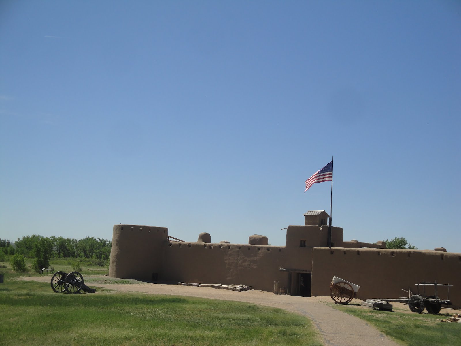
Pipe Springs is a natrual spring whose source is the mountains of Utah. Water has leeched down through layers of the earth only to pop out at this spring near Freedonia, AZ. It has been used over the centuries by natives, Spanish and travellers. The Mormons used this site as well and Brigham Young spent time here. Some of the fundamentalist sects are located near this site.

Here are the rebuilt bunkhouses for the ranch...

Ranch house with the spring...

Another visitor...

From there, our next destination was Mountain Meadow. On the way, we passed through Colorado City, a fundamentalist community, and St. George home of the 2nd largest LDS temple in the state.

Here's Judy having her lunch at a scenic overlook north of St. George.

We arrived at Mountain Meadow and had plenty of place to park. I don't think this is a heavily visited site.

But, we weren't the only visitors...

The monument marks the grave of 100+ men, women and children who were massacred by a band of Piaute and local Mormons. The Mormons were paranoid of anyone passing through this area at the time especially people from Arkansas where the Mormons had been persecuted. After all the investigations, one person, John D. Lee, the person who built Lee's Ferry across the Colorado at the "official" beginning of the Grand Canyon, was executed for the crime. More details can be found on-line.

Before heading to Vegas, we made one last off-road trip on the Joshua Tree Road. This scenic by-way runs through the Shimvits-Piaute reservation. Many of the Joshua trees were burned in a fire a few years ago, but it was still an enjoyable ride.

It is hard to find a sign out in the boondocks that isn't riddled with bullet holes.....

Some of the trees have sprouted new growth...

We did make one wrong turn and ended up here. Doesn't look much like a road. It is the way to an old mine that has been closed

And, oh yeah, some of the cactus were in bloom...

From there we found I-15 and headed to Vegas. We were too late for our reservation at Mon Ami, a French restaurant we like, but made it to the David Spade show (a good show if you like David Spade. I do.)

For me Vegas is like Building 19. It seems like a good idea to go there, but once you are there, you say "what am I doing here?" But, I'm sure I'll be back.