Sunday, April 29, 2012

Family Visit - Round 2

Our next set of visitors was the 3 former Boussy Girls, Ann Frazier, Terry Hathaway and Carol Pistorino. Terry was the first to arrive, overlapping with the Murdochs who stopped in Sedona at the end of their great trip. Ann came in on Monday and Carol, fresh from her trip to the orient, arrived on Wednesday.

As their time in Sedona was short, they didn't plan on any side trips, just lots of relaxing, hiking, eating and the occasional adult beverage. They were great company doing most of the cooking and cleaning while they were here. Judy was in heaven.

Our first hike with Terry was to Wilson Canyon. This is a great, first day hike. It is a little over 3 miles, R/T, and has a nice rolling, shady trail. The trail begins at the Midgely Bridge. At the end, there is a path way to the top of a hill that gives great views of Munds Mountain. This was a perfect way to start the week.

Once Ann arrived, the 4 of us took the Marg's Draw trail for Ann's warm-up. Here are Ann and Terry at the turn around point on the trail. This is about a 3 mile R/T if you take a couple of the spurs, which we did.

The next morning, we hiked the Little Horse to Broken Arrow trails, so we dropped the Jeep at one end at the Broken Arrow trail head and took Terry's car to the other end at the Little Horse trail. From Little Horse, we hiked up to Chicken Point and then down Broken Arrow to the parking lot. This is a great way to hike these trails. The 360 degree of views of Red Rocks on the Broken Arrow trail can't be beat.

Here's Cathedral Rock viewed from the Little Horse Trail.

Two sisters below the Two Sisters....

Resting before climbing Chicken Point.

Panoramic view from the Broken Arrow Trail

Before leaving Broken Arrow to pick up Terry's car at the Little Horse trail head, we took a quick Jeep ride. Here we are coming down one of the slick rock areas at the beginning of the trail.

After Carol arrived, we took the Soldier's Pass trail on Thursday morning. This has some natural sites like the Devil's Kitchen and 7 Pools as well as a nice rolling shady trail. I always enjoy this trail.

Here they are posing near the Devil's Kitchen

At the Juniper growing out of the crack in the rocks at the 7 Pools...

And somewhere along the trail. Great spot for photos.

We wanted to have a picnic after the Soldier's Pass hike but it didn't come off quite as planned. We ended up eating our New York Deli sandwiches at the house and then took a Jeep ride down towards the old Homestead. At one particularly "dangerous" part of the trail, Ann and Terry decided to walk around the "ledge" and meet us at the bottom. They walked up on the way back too. Carol and Judy threw caution to the wind and stuck it out with me. Here's what they were missing...but, the photos don't do it justice

And from the back...

The last hike was on the Mund's Wagon Trail. We started at the Schnebly Hill parking lot. It's hard to imagine that someone might have run a wagon on this trail but it was fun to hike on. There was a little bit of water in the washes...

Time for a photo op...

A little relaxing on the trail...

And, of course, great scenery...

This trail wends its way along the dirt Jeep road so there are plenty of spots along the way to bail out and walk the Jeep road back to the parking lot. At about 1.5 miles, Judy, Ann and Carol decided to walk back while Terry and I went about another mile to the Cow Pie area before turning around. Terry kept commenting on how much she was enjoying the hiking and would love to spend more time in Sedona. Last year Kaleigh, Mia and I hiked this part of the trail during their visit. Judy had dropped us off at the top end of the trail and Kaleigh, Mia and I hiked the 4 miles back to the parking lot.

How can these trees grow out of a little crack in the rock?

Our meals were great too. Terry made Curt's famous tomato sauce one night (both mild and hot versions). Ann turned that into a casserole on another night. We all went to Harry's Hide-Away in Cornville for dinner one night and thoroughly enjoyed it. Plus burgers on the patio with Terry handling the grilling.

On the last day, the girls took Judy to lunch at L'Auberge, a beautiful creek side resort. It was a terrific way to end the mini-vacation.

We had a great week of hiking, reading, jeeping, eating, imbibing and relaxing (with the occasional conference call). We all enjoyed it and the girls are all looking forward to the next adventure.

Sunday, April 22, 2012

Family Visits

Over the past few weeks we've had a few rounds of visitors here in Sedona. First, our niece, Jackie, and her friend, Jose, stopped by for a few days on their way on an action packed tour of the area. Jackie is a nurse at Brigham and Womens' Hospital and Jose is a doctor there. When their schedules lined up they headed west.

They arrived on a Thursday night in a bright blue Mustang convertible. Judy had prepared Chicken Marbella which was delicious. We just relaxed over dinner then sat on the patio and took in the dark western sky.

The next day we brought them on a hike through Soldier's Pass up to the Brins Mesa trail and then down to the Vultee Arch road. Judy met us there in the Jeep. On the way back for lunch, we dropped Jackie and Jose at the trailhead for the Devil's Bridge which they thoroughly enjoyed.

After lunch at Nick's, we drove out to the Honanki ruins. Everyone has to see some of the ruins of cliff dwellers when here in Sedona.

From there, we took the back road through Loy Canyon and back to town. All this followed by cocktails on the patio and a nice fire in the fire pit.

The next day, Jackie and Jose wanted something a bit more substantial for a hike. So, I suggested they tackle the Huckaby Trail from the Midgely Bridge to Schnebly Hill, then hike to the top of the Munds Wagon Trail and back. Here is Jose helping Jackie across Oak Creek at the beginning of the Huckaby

It was a long hike and they pooped out around the trailhead for the "cow pies" where I picked them up. We drove up Schnebly Hill for some of the views and then came back to our place. They showered and went to Tlaquapaque where we met them for a late lunch at El Rincon.

They next day, they played golf at the Sedona Golf Resort and had a great time. After that, they came back to our place where we watched The Masters and they "finally" left on their 3 hour trip to head for the Slot Canyons of Page and then the Grand Canyon. Jackie will have to provide photos of that part of the trip.

After the Canyon, they drove back to Phoenix for a few days at the Wigwam Resort. We decided to take in a few cultural events in Phoenix, so we drove down and met them for lunch at the Heard Museum.

Don't they look like a nice couple? We had a very nice time with them and look forward to getting together at home.

Monday, April 16, 2012

Many Faces of the Thumb

The view we get from our living room window is of the rock formation called The Thumb. From our perspective, it looks like a thumb. From other angles, it may blend in with other formations surrounding it. But, here is a sequence of a number of transformations the Thumb may go through over time.

Typical view with a little stormy weather on the way

A typical sunset.

How about a little snow on The Thumb

Here is a sunset with the full moon rising....

Then the clouds on the horizon opened up and we got a glorious sunset...

Finally, on a day when storms rode through all day, we caught this sight at the end of the day.

You just never know what you are going to get for spectacular scenery from one moment to the next here in Sedona.

Thursday, April 12, 2012

Comb Wash and Moki Dugway

Off of route 163 between Bluff and Mexican Hat is San Juan County Road 235, the Comb Wash Trail. This easy trail runs on the west side of Comb Ridge between rtes 163 and 95. Comb Ridge is a "monocline" that runs almost 80 miles from Elk Ridge in the north down to Kayenta, Arizona in the south. A monocline is a "bending of the earth's crust" in one direction only. From the east side, the ridge looks like a series of individual slanted hills. But, from the other side, one can see that the ridge was pushed up because sheer cliffs are on the other side of the slanted hills. This wash drains water from the north and from the Cedar Mesa on the west.

We drove about a mile or so then took CR237 (called Snow Flat Road), over Cedar Mesa. Snow Flat Road was part of the old Mormon Pioneer Trail that led to San Juan. This road, about 20 miles long, had terrific vistas in all directions as you got towards the top of the mesa. Near the very top, the road got a little more challenging but nothing the Jeep couldn't handle. Here we are passing over a sketchy section near the top.

Once on top of Cedar Mesa, we had clear sailing, only seeing a few vehicles coming in from the other side, until we reached route 261. Taking 261 south, we were heading for the Valley of the Gods which we had visited before with the Nobles. As soon as we saw signs pointing to John's Canyon, I knew we must be getting close. But I wasn't quite prepared for what was ahead. We could see Monument Valley way off to the south but couldn't see anything of the Valley of the Gods which should have been just to our left. That was because we were on top of a large plateau and the rock formations were in the "valley" below.

When we saw the signs warning trucks of a steep descent

and then the paved road turned into a gravel set of switch backs that dropped us from the plateau to the valley floor.

This was the Moki Dugway.

Here are a series of swichbacks that drop you 1100 feet.

The road was built in 1958 to transport uranium ore to a processing plant in Mexican Hat. It really was amazing to be driving along on a seemingly flat road and suddenly hitting this steep drop. But, it is very typical of the landscape in this area. There might be steep cliffs on one side of the road and a very deep canyon on the other. The way the land has been created, layer by layer, over millions of years and then patiently eroded over more millions of years is astonishing.

Sunday, April 8, 2012

Natural Bridges National Monument

A little further west on rte 95, about an hour from Blanding, Utah is the Natural Bridges National Monument park. There is a very nice visitor center at the entrance to the park. We talked to the Ranger to ask about taking some of the back roads over the mesas to get to the southern end of Canyonlands. He said there was a lot of slippery mud and snow still on the high areas and had recently slid off the road in his own Jeep. He was stopped by a tree and some rocks from going over the edge. We decided to heed his advice and stay off the high road.

There is a short video at the Ranger Station that explains the origin of the Natural Bridges. Unlike others that were formed more by wind and water, these bridges were formed mainly by rivers cutting new paths through the area. The bridges were of different ages as can be determined by the thickness of the bridge and the size of the opening. The thicker the bridge, the younger/newer the bridge. There is a 9 mile loop that takes one to scenic overlooks of the bridges, like this one called Sipapu, which is the name for the hole in the earth from which the Hopi's ancestors emerged.

There are a number of trails that lead to the base of the bridges. One can hike up and down at one bridge or hike connecting trails to cover all the bridges. We hiked down to view Owachomo Bridge. Here is a photo of Judy and Sarah making their way to the base of Owachomo Bridge.

At the base, Bill and I made our way to a small pool to try to get a reflection of the bridge in the water. There wasn't much water and it was a little slippery getting down the slick rock to the edge of the water to try to get this photo.

This was a very nice little park. One could take in the beautiful sites from the overlooks or take the more adventurous hikes from one to another. It was on my list of places to get to in Southern Utah and it was well worth the detour.

Because we decided not to cross the "Bear's Ears" to get to Canyonlands, we took the northern end of Butler's Wash along the Comb Ridge back to Bluff for the night. Cocktails on the porch and dinner at the Cottonwood Steak House to end the day.

Saturday, March 31, 2012

Flaming House Ruin

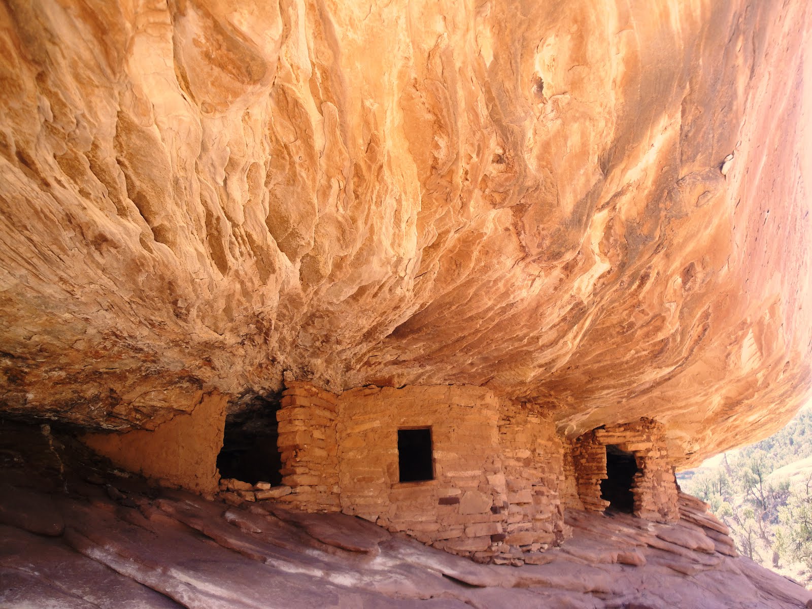
Our next stop was to find the Flaming House Ruin. This ruin is located in a canyon off of rt 95 west of Bluff. The images of this ruin that one finds online are spectacular. In reality it is not quite as spectacular but it is still mighty impressive. After a leisurely half hour walk criss-crossing a dry creek bed we reached the path up to the ruin. Luckily the creek was bone dry as we crossed it many times and even walked in the creek bed. In the rainy season, it would be pretty messy hike. There is a very short bit of slick rock to climb up to view the ruin. There are several dwellings snuggled under an overhang. The sun reflecting off the slick rock lights up the overhang, giving it the name Flaming House Ruin. The photo to the left was taken around 11am before the sun came over the overhang.

There are many such ruins in the 4 Corners area. They were inhabited by the Anasazi for about 800-900 years until they abruptly picked up stakes and moved toward the south. The reason for that is unclear but most archeologists feel that it was due to a sustained drought.

There were a few nooks and crannies that it was fun to poke around it...Here's Judy thinking about doing some climbing

And I got a little wedged under a boulder and was about to go all "127 Hours" when Judy reminded me that I could easily just pull my arm free.

On the way in the canyon, we spotted this rock which reminded us of one of our favorite books, Angle of Repose, by Wallace Stegner. With a little more angle, this particular rock won't be reposing much longer.

Thursday, March 29, 2012

Butler Wash near Bluff Utah

Butler's Wash runs along the east side of the Comb Ridge in southern Utah. It runs south to north from rte 163 near Mexican Hat to 95 near Blanding. The Sullivans and the The Donovans drove in from the southern end. We were looking for the Wolfman petraglyphs in a small canyon along the trail. After about a mile, there is a dirt road on the left just before the first cattle crossing. It leads to a small parking area and further to a area of slick rock just before a path that should lead one to Anasazi wall art.

We parked the Jeep on the slick rock and followed the trail, what there was of a trail.

The area is noted for the Wolfman petraglyph which was not that obvious to find. We walked around the ledge looking across the ravine trying to spot the wall art. On the opposite side of the ravine are a few ruins. Here's Judy looking across the way at one of the ancient cliff dwellings.

Using binoculars, we finally located the wall art which was a distance away. After climbing over/between some huge boulders, we picked up the trail that lead from the left end of the slickrock. The pathway led along a narrow trail hugging the ledge and then beyond a large alcove. The wall art was located in the dark patch of desert varnish located to the right of the alcove.

Bill and I worked our way along the ledge and under the alcove to come to the Wolfman art work. Here's Bill heading down from the alcove to get a view of the wall art.

This site was definitely worth the detour. It took a bit to actually find the wall art, but we are glad we persisted. Here is a great example of wall art from the Ancestral Pueblans

Sunday, March 25, 2012

The Oak Creek Homestead Trail

The Homestead trail is a very interesting and difficult side trip off of one our favorite drives. We have taken most of the 9845 route before and it has some interesting scenery and it is close to town. We follow 9845 from 89A about a mile south past Upper Red Rock Loop Rd. At a junction of about 4 trails, we turn right onto 9845H. I assume the H is for Hard. In fact, this part of the trail is rated Extreme on my Red Rock Ranger District map. The trail winds its way up and down over fairly large rocks along a shelf overlooking a canyon below. I had to pull over to the edge of the shelf to let an oncoming tourist vehicle get by, which was a little disconcerting.

We had been to the beginning of the extreme section before, but opting not to try it as it was late in the day and I didn't expect anyone else to come by to help in the unlikely event that I might have needed assistance. This time the Kobeys were with us and Lynn urged me on. The road drops down a relatively steep ledge with huge drops between the boulders. It was short but sweet. Once down the ledge the trail leads to an old abandoned homestead. Here's Lynn checking it out.

At some point I'll get some photos of the crawl down and up the rocky ledge. But, in the meantime, the trail leads to a campsite along Oak Creek and the trail crosses the creek and picks up on the other side. Here we are contemplating the creek crossing.

Discretion got the better part of valor and we did not cross the creek. It really wasn't much a choice as we thought the creek must be fairly shallow but couldn't see the bottom. With no other Jeep to help us get out if we got stuck, it wouldn't have been a good idea to try it.

But there was beautiful scenery along the creek.

Sycamores

And a really cool rope swing that looks like it could be fun (for someone other than me!)

We have been back there one time since to have a picnic. We even bought some camp chairs at ACE even tho we have at least 3 at home. So we pulled up to the edge of the creek and unloaded and set up the chairs. Then I kiddingly asked Judy where the lunch was. After scouring the back of the Jeep we realized we had left it on the counter. So, what else to do but read for a bit and then go out to lunch at one of our favorite local spots, Nic's.

BTW, check out the color of the creek in the photo on the right. This was taken on our first trip here while the photo above were taken on the second trip. After the snow storms here a week ago, there is a lot of runoff that adds a lot of mud and silt to the creek and raised its level quite a bit. Interesting to see how quickly the creek can swell from snow melt and runoff.